5 min read · September 16, 2026
Why California is an island on so many antique maps
For roughly 150 years European maps showed California as an island. The error was corrected, published, ignored, and re-published. It is the best case study there is in how map mistakes actually spread.
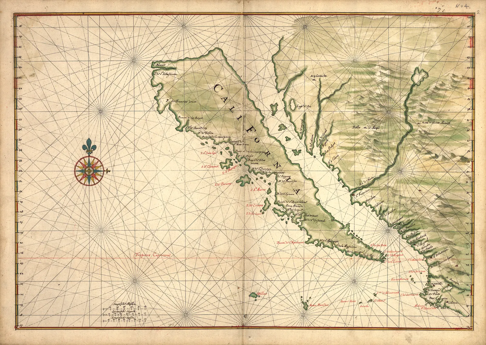
It is the most persistent mistake in the history of mapmaking, and the interesting part is not that anyone made it. It is that it was corrected, in print, by people who had been there — and then kept appearing for another century.
Where it came from
The Gulf of California is long, narrow and runs almost due north-west. Sail up it without reaching the end and the obvious inference is that it continues, and that the land to your west is separated from the mainland.
Several early voyages reported exactly that. A 1602 expedition under Sebastián Vizcaíno produced charts that were read as showing an island, and a description in a 1622 Spanish account hardened it. By the 1620s the island was appearing on printed maps, and once a shape is engraved on a copper plate it has enormous momentum: plates were expensive, they were re-used for decades, and later publishers copied earlier ones because that was the economics of the trade.
It was corrected almost immediately, and ignored
In 1701 the Jesuit missionary Eusebio Kino travelled overland and reached the head of the gulf, establishing that California was joined to the mainland. He published. Ferdinand VI of Spain issued a royal decree in 1747 stating plainly that California was not an island.
Maps kept showing the island into the 1750s and beyond. Herman Moll — one of the best-known London mapmakers of the period — was still publishing the island decades after Kino, and on at least one sheet added a note asserting it on the authority of a sailor who claimed to have circumnavigated it.
The reason is not stupidity. It is that a map was a commercial product assembled from available sources, and a spectacular, memorable, already-engraved coastline was worth more to a publisher than a correction from a missionary in a place nobody in London had been.
What it tells you about reading old maps
Three things, all of which make them better to look at.
A map is a record of belief, not of geography. The date on the sheet tells you when someone thought this; it does not tell you what was there. That is precisely why they are worth hanging — you are looking at what a specific person in a specific year understood the world to be.
Blank space is honest, and filled space often is not. Cartographers who left interiors empty were usually telling the truth. The ones who filled them with mountain ranges and lakes were frequently guessing, and some of those inventions — a great western river, an inland sea — survived for generations for the same reason the island did.
Decoration carries information. The sea monsters, ships and wind heads are not only ornament. They mark trade routes, claimed territories and the limits of knowledge, and they were often the most expensive part of the engraving.
The ones worth looking at
Our California as an Island sheet is the classic statement of the error: the island drawn confidently, with a strait where none exists.
The Blaeu world map of 1664 is the high-water mark of Dutch Golden Age cartography — two hemispheres, allegorical borders, and errors everywhere, all of them period-correct. It is one of the largest files we hold, 6,782 pixels on the long edge, which is why it stands up at 32 × 48 inches.
Moll’s map of the West Indies is from the man who kept publishing the island, and shows how good the rest of his work was.
Everything in the world maps collection is printed from a public archive’s own scan, with the institution named on each product page. We do not sell antiques and never describe these as such — what you get is an honest print of a specific surviving sheet.
Sources
Where this came from
- Library of Congress — California as an island
- Stanford Libraries — Glen McLaughlin Map Collection: California as an Island
- Library of Congress — Blaeu world map
Corrections are welcome and we publish them — info@antiquemapprints.com. Nothing here is generated from a template; if something is wrong it is our mistake, not a machine's.


